

As a vital channel for commerce and travel, it is impossible to overstate the importance of the Mississippi River in 19th century America. As part of the river’s history, this week marks 162 years since a pivotal Union victory in the Civil War: the Battle of Fort Jackson and Fort St. Philip, and the capture of New Orleans and the lower Mississippi River. Several fascinating maps drawn at multiple scales provide us with an in-depth view of this battle and its aftermath.
The Mississippi River passes through New Orleans and meanders a further 100 miles southeast before emptying into the Gulf of Mexico. Closer to the mouth of the river in Plaquemine Parish are the sites of Fort Jackson and Fort St. Philip, established to defend New Orleans and control of the river. A closer view of John Bachmann’s 1861 Birds eye view of Louisiana, Mississippi, Alabama and part of Florida provides an artistic rendering of this geography.
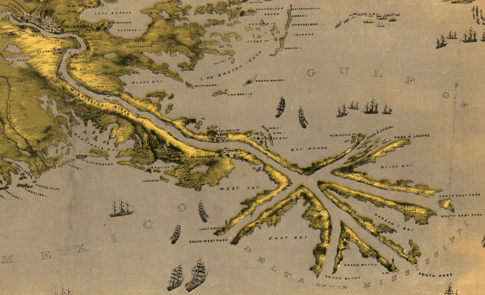
Military defenses in this location have a long history. Before Fort St. Philip, the site was Fort San Felipe, an installation built in the 1790s by the Spanish, who administered Louisiana as a part of New Spain. Under American control following the 1803 Louisiana Purchase, the fort was expanded and would resist British bombardment during the War of 1812. In the 1820s, Fort Jackson was constructed on the directly opposite riverbank, further bolstering defenses in the area. Both forts were located along a sharp bend in the Mississippi River, which was key to their strategic value. Enemy ships needed to slow down and hug the riverbank to pass through this stretch of the river, making them highly vulnerable to attack.
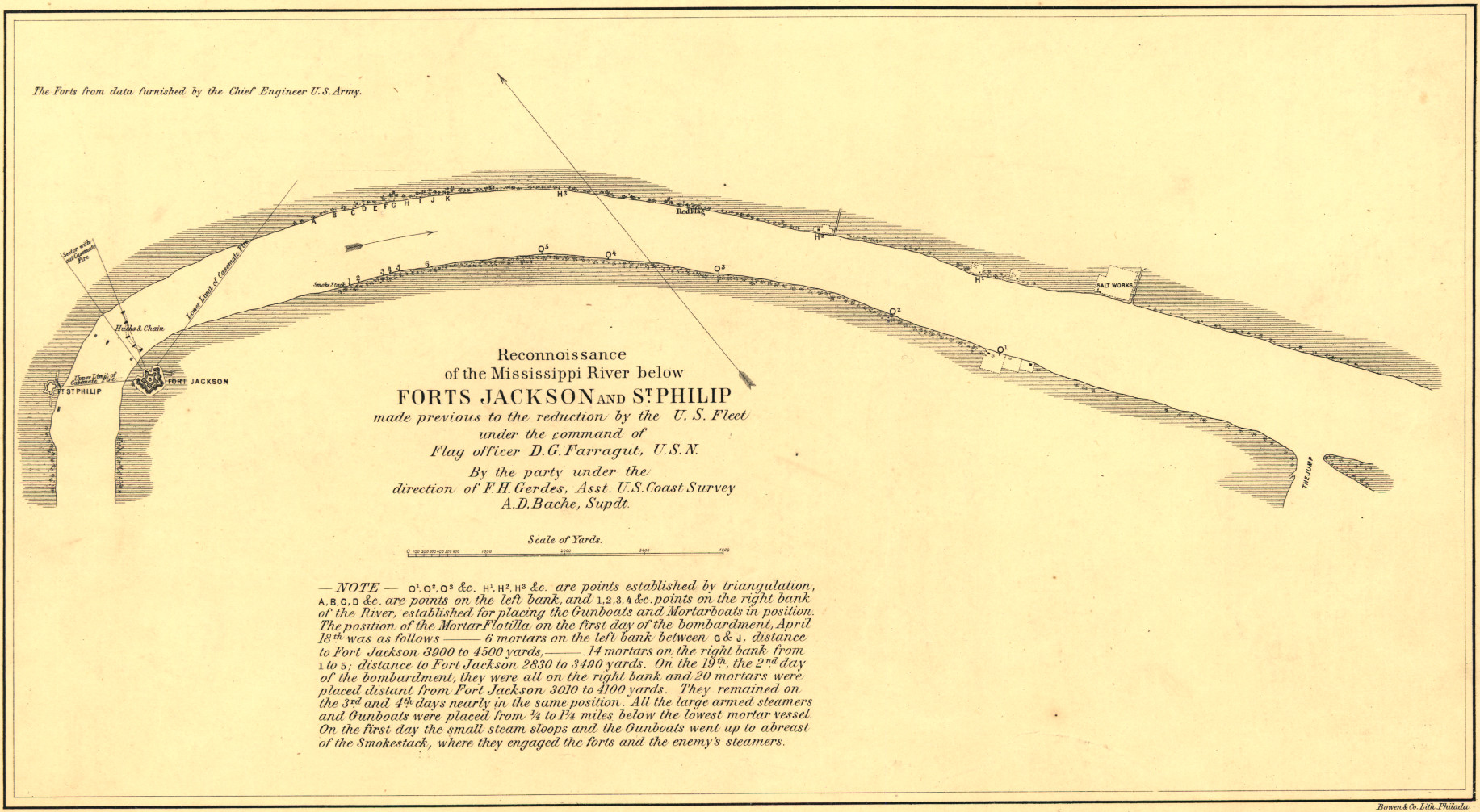
After the outbreak of the Civil War brought Louisiana and its forts under Confederate control, Union military strategy would soon focus attention on controlling the lower Mississippi River via the Gulf of Mexico. Under the command of U.S. Navy flag officer David G. Farragut, reconnaissance operations began in early April 1862 to scope out the positions of Forts Jackson and St. Philips in relation to the river bend. The map below is one of several in our collection documenting the reconnaissance efforts.
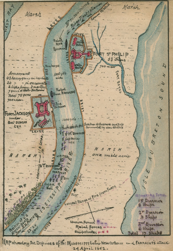
After several days of reconnaissance, Union vessels began a heavy six-day bombardment of the forts. With the forts weakened but not surrendered, Farragut ordered several of his gunboats to break riverine chain defenses and prepare to pass by the forts. In the early morning of April 24th, Farragut began to lead his fleet single file through the broken barriers. The Union Navy would come under heavy fire over the course of the day, but was ultimately able to pass the forts with most of the fleet intact, while inflicting significant losses on Confederate ships. Robert Knox Sneden, a prolific cartographer for the Union Army, would illustrate the battle’s geography in his distinctive watercolor style.
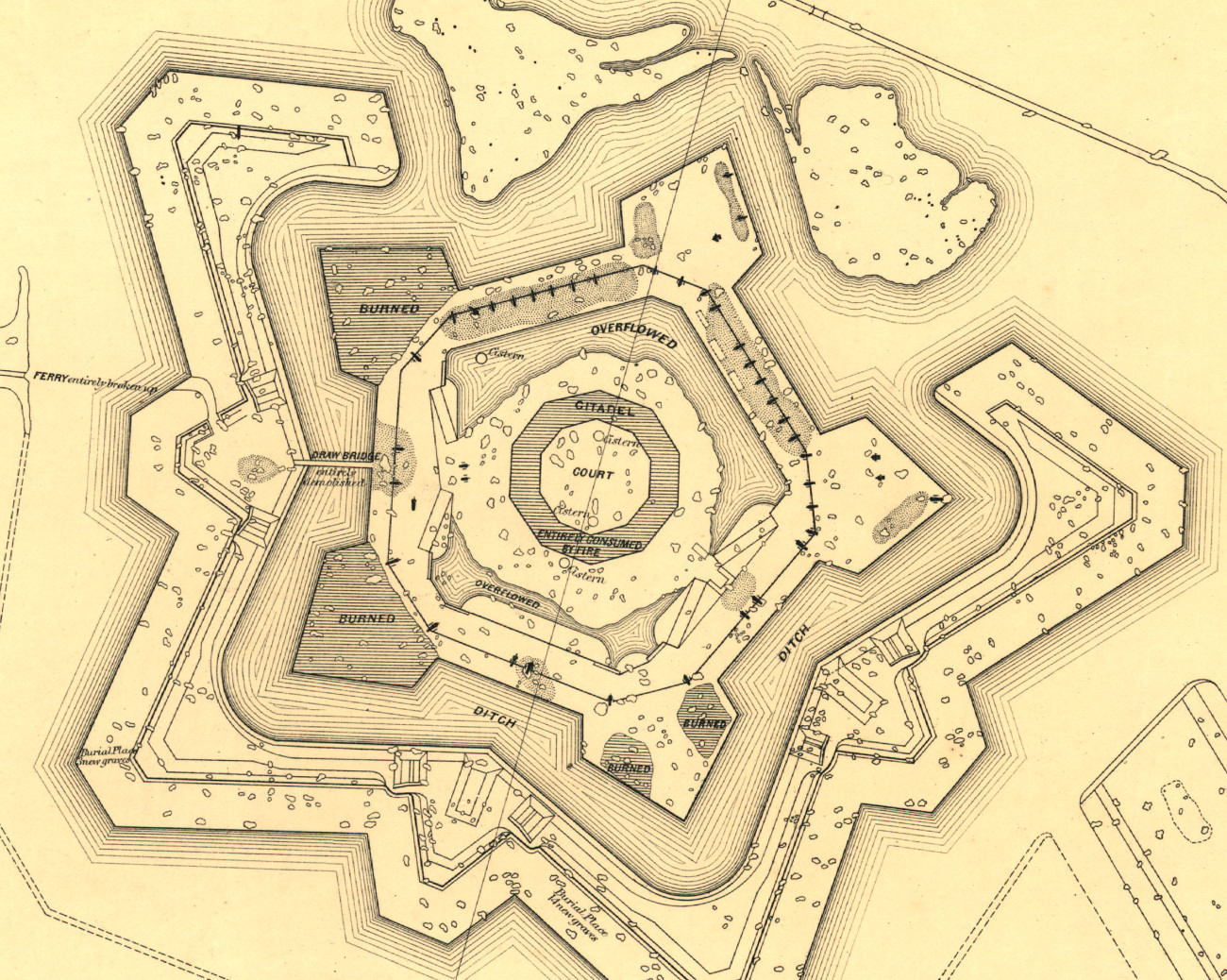
With the primary defenses of New Orleans now breached, Farragut’s fleet wasted no time in continuing up the river towards the city. By the end of the following week, New Orleans, Fort Jackson and Fort St. Philip would all fully surrender to Union forces. A map of Fort Jackson produced by the U.S. Coast Survey in the battle’s aftermath provides an incredible level of detail into the damage the fort sustained, from areas burned by fire and inundated with water from broken levees, to individual holes in the fort walls created by Union mortar fire.
The Battle of Forts Jackson and St. Philip, and the subsequent capture of New Orleans, mark a key milestone in the Civil War. Union control of the mouth of the Mississippi River was a major accomplishment in Union General Winfield Scott’s “Anaconda Plan,” which sought to economically and diplomatically isolate the Confederacy from the outside world. This incredible series of maps help us to understand this important moment in the conflict at many scales, from the contours of the region to the holes of bombardment in a fort wall.
Discover More:
- Learn more about John Bachmann and his incredible “bird’s eye views” in a 2022 Worlds Revealed blog post by Meagan Snow.
- Robert Knox Sneden produced hundreds of maps of Civil War engagements. Explore his maps in our online collection, or dive deeper into the stories behind the maps in the Worlds Revealed blog.
- Our Worlds Revealed blog series Places in Civil War History explores maps produced during the conflict.
- Explore our vast collection of Civil War maps online, along with a series of essays on Civil War mapping history.
Source: https://blogs.loc.gov/maps/2024/04/the-battle-of-forts-jackson-and-st-philip-through-maps/